The tour starts with a 10-minute journey by bus from Mariastein to Unterlangkampfen (bus schedule on
www.vvt.at)
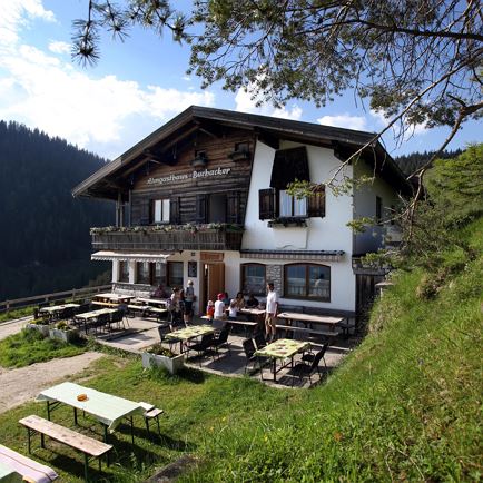
Above the church in Unterlangkampfen there is a signpost leading to “Höhelnsteinhaus”. Follow the sign along the forest track and turn right soon after into a cart track. Now the route runs along a steep path through the forest. Shortly before the arrival at Höhlensteinhaus you get to an open alpine pasture from where you can see the Höhlensteinhaus in the depression below. Right by the Höhlensteinhaus there is a path leading to “Köglhörndl” (1645 m). The route now runs along a primitive and steep path through the forest in a romantic and lonesome area up to the ridge and over it to Köglhörndl and the summit cross. From there the path leads again downhill into the forest. Now the route runs up and down to Hundsalmjoch (1637m) and its modern summit cross. Leaving the ridge the route leads now right opposite the summit cross on a marked path down to the alpine pasture area. The tour goes on through meadows and leads then via a shortcut on the left to a forest path which takes us down to the alpine inn Buchacker. From the inn we hike down the forest track for another kilometre until the junction where the Adlerweg Trail turns right to Kaiserhaus. Stay on the forest track which winds down to Mariastein in several bends. At the last right turn where there is the signpost for Buchacker and the Eishöhle (ice cave) take the path downhill until you get to a small chapel. Turn left there into the Chapel Walk (Kapellenweg). Then walk along the road for about 1.8km back to Mariastein.